Pilot’s Backpack Trip Turns Educational
Gary Gillespie, September 2006
“It was the worst day of my life. Holed up under a fir tree at dusk, we had just finished forty-eight hours of evading in the rain. My body was literally shaking from the cold,” he said while we listened to the story around the campfire.
“It was the worst day of my life. Holed up under a fir tree at dusk, we had just finished forty-eight hours of evading in the rain. My body was literally shaking from the cold,” he said while we listened to the story around the campfire.
“I assessed the situation and realized that I could either risk it by pushing through the brush to the set coordinates before the deadline, or stay put in the storm and conserve energy. There was no way I’d make the last five klicks and complete the exercise as planned. I updated my position, reached for the radio and requested a recovery.
“If you want to survive in the woods, you’ve got to think before you act.”
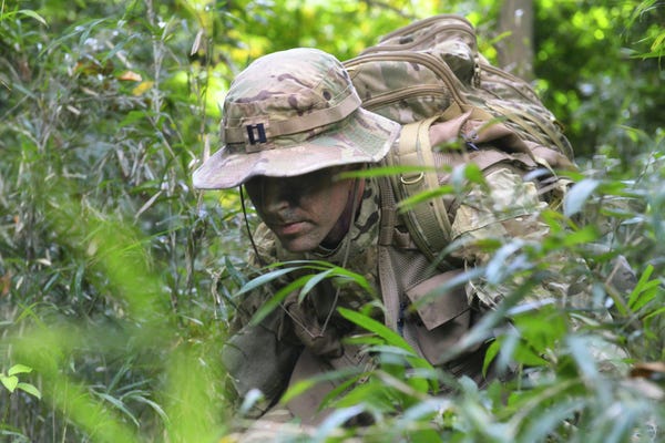
It was one of the many lessons shared by Major Brent Gillespie on a five day August backpacking trip near the Canadian border in Washington State’s Pasayten Wilderness.
 |
| Pasayten Wilderness |
The trip was offered as part of a physical education course for students at the University where I teach in the Seattle area. When only two students signed up, I was pleased that Brent agreed to serve as our survival instructor anyway.
An enthusiastic hiker who has trekked across the European Alps and Dolomites mountain ranges, the Mt Cook glaciers in New Zealand, the Grand Canyon and most of the Crest Trail in his home state of Washington, he said that he never turns down an offer for a wilderness excursion – especially so close to home.
I was also pleased because it gave me a chance to spend a week with my younger cousin who I’ve heard so much about but didn’t know very well.
 |
| Brent Gillespie at Mountain Tarn |
During the trip “cool!” was an often heard remark by the students when Brent teachings were illustrated with such survival tools as a pocket sized Air Force manual, a compass and maps of the region, a GPS device that registered our position and tracked our day hikes perfectly, and a thin eight inch green cloth pouch that pilots always carry in case of being shot down — filled with all that is needed to survive in enemy territory.
But, the coolest device was a pair of night vision goggles. The NVG’s lit up our lake camp at night, causing dim trees surrounding the campfire to glow white as if hit by a spotlight and showing every star, satellite and even a fuzzy galaxy precisely spangled across the sky. It was literally an eye opener. We learned that this NVG technology is why the US military is said to “own the night.”
and Bosnia. During his career he has trained pilots for wilderness survival. He is a graduate of Air Force Combat Survival School and Water Survival School and in 1998 he took part as a test subject for Operation Woodland Cougar, a strenuous four-day escape and evasion exercise. He was the ideal instructor for the class.
Adding another branch to the fire, we listened as he continued about the time he volunteered for Operation Woodland Cougar somewhere in the Colville National Forest in the northeast part of Washington.
Serving in the less than desirable location of Korea at the time, he figured that volunteering for the escape and evasion exercise meant a ticket home. He didn’t point out that he had spent most of his summers in high school working in the same forests and knew the area well.
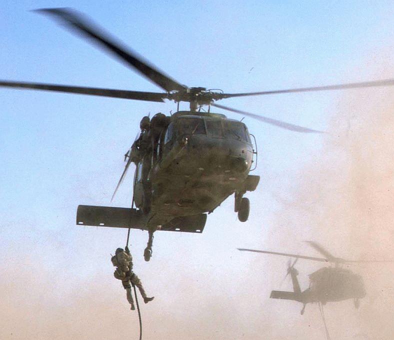
After calling for recovery, the commanders sent a helicopter delivered SEAL team to pick him up because of the poor weather and darkness. But for some reason the team couldn’t find his location where he sat with a Navy SERE observer (Survival, Evasion, Resistance and Escape).
“I guess my evasion skills passed the test, but at that point I no kidding wanted to be found.”
 |
| Brent's Office |
Hours later he finally heard the roar of an HH 60 helicopter above. When he mounted the helicopter’s extraction cable, he held on as tight as possible considering that his hands were numb from the cold, only to find that the he began to spin so fast that pieces of his gear went flying off in all directions before he was pulled in safely.
“I was spinning around like a cartoon character.”
We laughed at the image.
He said that back at base the debriefing lasted more than four hours, explaining that the Air Force not only uses exercises like Operation Woodland Cougar to provide realistic training for pilots who may be shot down, but carefully analyze every detail to improve escape and evasion procedures for the future.
 |
| Silver Lake |
Each day of our wilderness exercise we were given new lessons in survival. We learned how to make a shelter from fir bows leaned up against the base of a tree, how to make a bed of grass to insulate your body from the ground and where to place a fire to keep the shelter warm.
He pulled out a three by four inch single mirror with a small, transparent star in the middle and proceeded to show how to aim it at a distant sight.
“A signal mirror can be seen for fifty miles,” he said.
“When the plane tips its wings back and forth that means that the pilot sees you and that you should turn the signal away.”
 |
| Buck on Buckskin Lake Trail |
“Turn the tip in like a hook. When the animal struggles, the snare gets tighter.” Hang it on a pole where squirrels will find it easy to climb or in the path of a rabbit. Roast the meat over the fire for a meal.
Students were given one of two fish hooks from the pilot’s survival pouch. He pointed to the lake and said, “Use some of these unraveled strands of parachute cord as fishing line. Now your assignment is to catch dinner.”
Because I have been backpacking to this same lake for several years, I knew that catching a trout wouldn’t be difficult. Even with a regular rod and reel, we usually catch a fish every other cast. Sure enough one student — using a horse fly as bait — caught a seven-inch cutthroat in five minutes.
Brent searched the grass around the lake and brought back a handful of parsley like leaves.
“It tastes like celery.”
He gave us instructions on how to test wild plants to see if they are edible.
“Unless you are absolutely sure that you recognize it, don’t eat any berries,” pointing out many dangerous berries may look tasty.
“Don’t eat any hairy insects. Look for grubs or ants. Be sure to pinch off the heads of ants to prevent them from biting.”
 |
| Lake Trout |
“It tastes just like lemons,” he said.
Ants became our snacks for the remainder of the trip.
Not that we wanted for food.
The first night we dined on bacon wrapped sirloin steaks and Indian flat bread. For breakfast we ate real jumbo brown eggs and bacon with hash browns and perked Kona coffee.
Our best meals were pan-fried trout caught right from the lake. I put the eight cleaned trout – each about eight inches — in a large plastic bag with a package of buffalo wings seasoning mix and shook it until each fish was coated. The fish curled in the pan and tasted better than you can imagine.
Brent remarked that there are differing philosophies for backpacking. Some guys hike as light as possible, walk for fifteen miles each day, sleep without a tent and warm their freeze-dried food in a tin can with a candle.
“That is one extreme. The other is Gary’s way.”

Whatever your style, the Pasayten Wilderness is spectacular for backpacking and is one of the last places on the west coast where wood fires are permitted. Unless there is a special fire restriction, hikers may use established fire rings. Just be sure to keep it small and put it out with three buckets of water.
The week that we camped, the Tripod forest fire burned up more than 75,000 acres about twenty miles away to the east at a much lower elevation.
Our camp sat above the lake at the base of an avalanche shoot, so broken pieces of treetops for firewood lay within easy reach.
Our camp sat above the lake at the base of an avalanche shoot, so broken pieces of treetops for firewood lay within easy reach.
We enjoyed sitting by the fire, drinking coffee and cocoa long into the night, taking turns viewing the stars with the NVG’s and trying to match constellations with a star chart — and hearing Brent’s stories about military life.
 |
| Wolves are Sometimes Spotted in the Pasayten |
“There are three kinds of people in the world,” he said referring to a military allegory that he had read.
“Wolves, sheep and sheepdogs. Wolves are those who want to hurt the vulnerable. Sheep are the average people out there who don’t know that they are in any danger – like those who don’t understand that we really are at war.
“Sheepdogs are the third type of people – on guard for threats and willing to fight to keep the wolves away. That is how we in the military think of things. We’re sheepdogs.”
Being in the wilderness at night, the threat of dangerous animals was more than allegorical. Cougars, grizzly bears and gray wolves are said to inhabit the Pasayten — although after more than a dozen trips, I had never seen any. So, I was a bit surprised to hear that the day before Brent had discovered some bear scat two miles from our camp – noting that it appeared to come from “a really large bear.”
While it reached near freezing at night, the temperature during the day ranged in the upper seventies, making day hikes delightful. We walked up hanging valleys to explore a series of blue-green tarns and do some prospecting among broken rocks and granite boulders at the base of cliffs.
Standing on the shores of one clear tarn that spilled across a mossy meadow into a creek down the hills, I noticed the sound of bees buzzing in heather and every kind of wild flower.
 |
| Brent and Gary at Lake Anne |
The pyramided shaped Pasayten Peak dominates Buckskin Ridge – which was once a center for gold mining in the 1890s and the hills are networked with mineshafts still filled with antique equipment. A ghost town abandoned by miners when word reached them that gold had been discovered in Alaska sits silently two ridges from our camp.
Jagged and glacier topped mountains with names like Silver Star, Golden Horn, Cathedral Peak and The Needles surrounded our seven thousand foot perch in all directions. The top of the ridge the volcano Mount Baker can be seen in the distance. The trailhead where we parked our SUV is the highest place that you can drive in the state. The view of sweeping, glacier carved valleys that reach far into Canada is like view from an airplane.
This region of Washington State and British Columbia was originally known as Columbia.
Displayed at the Forest Service Station in the Old West themed town of Winthrop is a portion of a tree that once grew on a spot near the border. Carved on the tree trunk is a poem by “Parson Smith.” No one knows who he was — perhaps a miner or fur trader passing through these mountains who paused to whittle a response to the scenic beauty that still rings true:
 I HAVE ROAMED IN FOREIGN PARTS
MY BOYS AND MANY LANDS I'VE SEEN
BUT COLUMBIA IS MY IDOL YET
OF ALL LANDS SHE IS QUEEN
Parson Smith, June 6, 1886
When the last day of our course arrived, we broke camp, disassembled the fire pit, covering traces of our habitation as best we could, then hiked for three and a half hours back to the trail head. Climbing the last steep six hundred foot switch back, we were greeted by a pair of Peregrine Falcons soaring on the same high mountain winds that swept across the ridge and kept us cool in the August sun.
The SUV was a welcomed sight and the students taking off their packs congratulated each other on making it out in tact. “We did it. We survived the wilderness!”
We then drove down the steep, often one way, former stagecoach road that hugs cliffs and sharp turns with names like “Dead Horse Bend” for an hour before reaching the Mazama Country Inn for a night’s stay before returning to Seattle.
Thoughts of survival were forgotten in favor of the luxury of a shower, hot tub soak and meal at the Inn’s restaurant.
Brent’s wife and three and five year old sons who had been visiting relatives in the area met us when we arrived. Later he refused my offer to buy the family dinner, and asked for two checks when the seven of us sat down.
That night the students and I played board games, watched movies in the Inn’s common room and tasted some hazelnut cheesecake on the deck.
Early the next morning, after saying goodbye to Brent and thanking him for his instruction, I checked out of the Inn and asked the office manager Mary for the dinner bill for room thirteen.
“I want to put my cousin’s dinner on my bill. He wouldn’t let me pay last night. You can explain when he checks out,” I said.
“Tell him it’s for being a good sheepdog.”
Mary looked puzzled.
“He’ll know what that means.”
________________________________________________
About the Pasayten Wilderness
Designated a Wilderness area in 1968, the Pasayten spans 529,477 acres on the border between Washington State and Canada. This very wild country is marked by 150 peaks over 7,500 feet, more than 160 lakes and at least that many rivers and streams that spill across alpine meadows or cut through canyons with sheer walls. Rugged mountain ranges in the west flatten into plateaus toward the east. Its thick and diverse forests range from fir, cedar, and western hemlock to pine and larch.________________________________________________
About the Pasayten Wilderness
More than 600 miles of trails wait for the backpacker to explore — many appear gentle at the start, only to become endless switchbacks. The Pacific Crest Trail crosses the area north to south for about 32 miles. The Boundary Trail goes north from the southeast corner to stretch near the Canadian border for a total of more than 73 miles before joining the Crest Trail.
The Pasayten is home to the largest population of lynx outside of Alaska. Deer, mountain goats, bighorn sheep, gray wolves, and grizzly bears also thrive.
When to Go
Snow falls between October and May, and the hardpack may block the high western-side trails sometimes until early August. Eastern-side trails are usually free of snow by early July. August and September are best for most visitors.
Snow falls between October and May, and the hardpack may block the high western-side trails sometimes until early August. Eastern-side trails are usually free of snow by early July. August and September are best for most visitors.
Getting There
From Seattle dive north to the scenic Cross State Highway 2 for about four hours to the Methow Valley. Look for the road to Hart’s Pass and Slate Peak or Horse Shoe Basin.
From Seattle dive north to the scenic Cross State Highway 2 for about four hours to the Methow Valley. Look for the road to Hart’s Pass and Slate Peak or Horse Shoe Basin.
Lodging
Sun Mountain Lodge
800-572-0493
Sun Mountain Lodge
800-572-0493
Mazama Country Inn
800-843-7951
800-843-7951
Freestone Inn
800-639-3809
800-639-3809
Outfitters
Cascade Wilderness Outfitters
509-997-0155
Cascade Wilderness Outfitters
509-997-0155
No comments:
Post a Comment